Select your language from the drop down menu.


,-Kensington-Park,-Leabrook-and-Tusmore_project-image_canva.jpg "Draft Precinct Plan for Beulah Park, Hazelwood Park (part), Kensington Park, Leabrook and Tusmore")
Ensuring our suburbs and transport networks are safe, accessible, liveable and meet the needs of the community.
Left: This engagement includes the area of Hazelwood Park north of Greenhill Road only. Hazelwood Park south of Greenhill Road is planned to be included in future Precinct Plans.
Background
The Burnside City Master Plan (CMP) is the Council’s long-term vision for balancing growth with the protection of the city’s character and environment and guides Council’s transport planning. Ensuring our suburbs and traffic networks are safe, accessible, liveable and meet the needs of the community is a priority of the CMP.
Council is developing suburb specific Precinct Plans that highlight the actions Council intends to take to improve local transport safety, accessibility and liveability.
The Precinct Plans will address existing traffic and road safety issues and also propose opportunities for improvements to the streetscape, access to local places of interest, and to the environment.
In November and December 2023, the Council sought community input to understand local transport safety, accessibility and liveability issues, concerns and opportunities in Beulah Park, Hazelwood Park (part), Kensington Park, Leabrook and Tusmore.
Recommendations
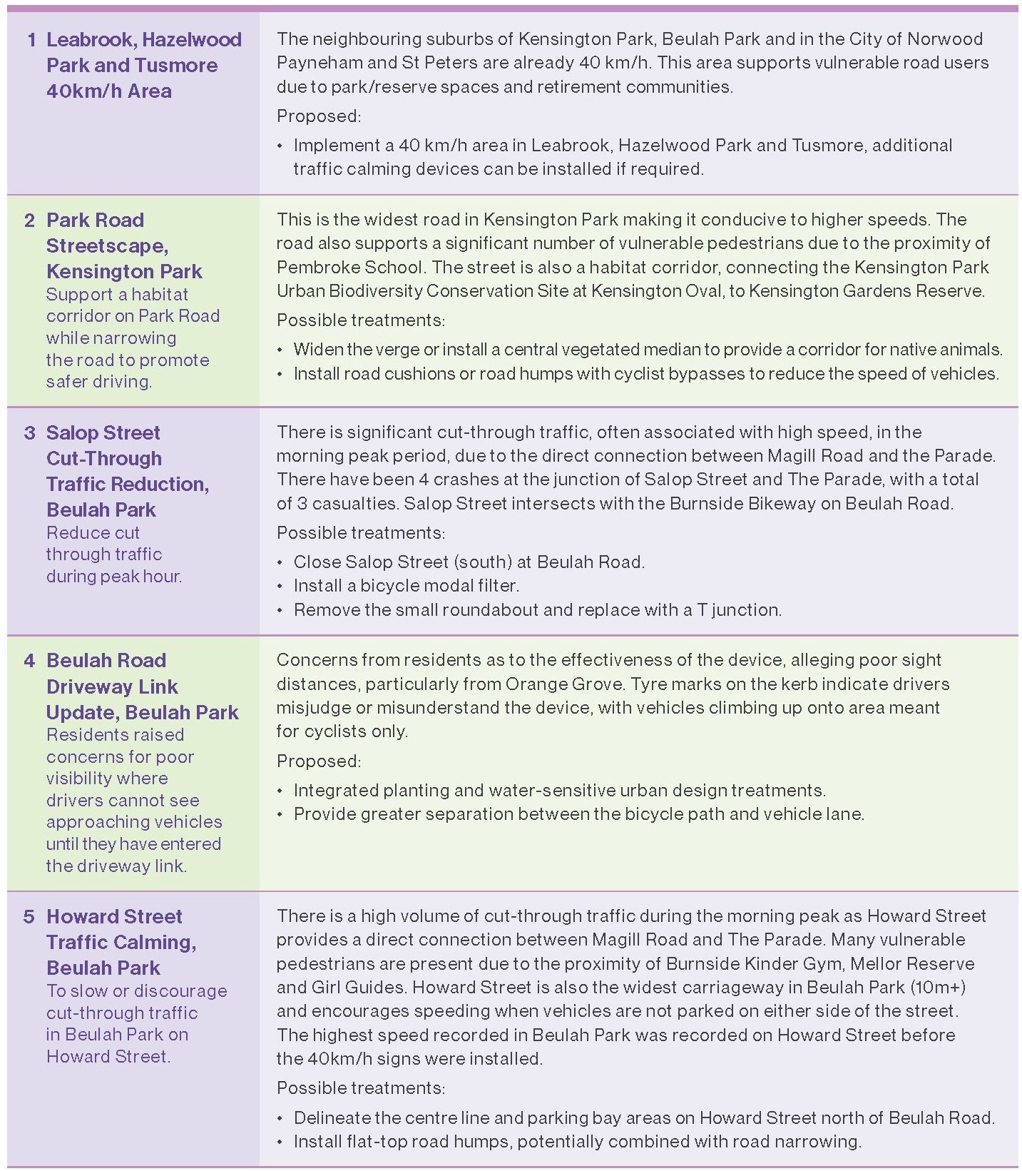
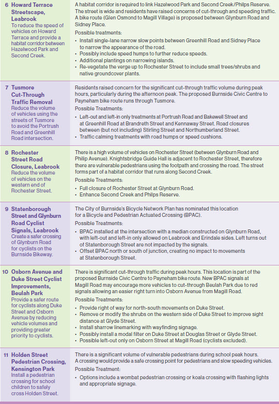
To resolve a variety of local traffic issues and improve streetscape amenity, 11 recommendations have been suggested. The detail for each recommendation can be found in the draft plan document. Visit the document library to the right of screen.
The 11 recommendations are summarised below:
Marryatville Precinct Master Plan
Adopted by Council in 2024, the Marryatville Precinct Master Plan is a joint project with the City of Norwood Payneham & St Peters, covering a section along Kensington Road from Maesbury Street to May Terrace. It aims to improve greening, tree canopy, streetscapes, traffic safety, parking management, people movement, activation and heritage protection. The Master Plan will also provide a more pleasant physical environment and improved traffic and people movement to attract more people and investment to the area and enhance the social fabric of the precinct and the community more generally.
The Marryatville Precinct Master Plan includes elements to address existing issues associated with limited off-street parking, traffic flow congestion along Kensington Road, difficulties travelling north-south via Shipsters Road and Tusmore Avenue, and pedestrian safety crossing Kensington Road and at side street intersections. These elements include the replacement of the existing signalised pedestrian crossing on Kensington Road between Shipsters Road and Tusmore Avenue with two new synchronised crossings, supported by alteration to road lane configurations. The Master Plan also recommends footpath widening, powerlines undergrounding, tree plantings, landscaping, and on-street parking changes to improve pedestrian safety and amenity. Overall, the Master Plan will create a sustainable and vibrant mixed-use precinct that offers greater diversity of housing, shopping, recreation, and entertainment.
The elements and improvements presented in the Marryatville Precinct Master Plan have been integrated with the treatments proposed in the Precinct Plan for Beulah Park, Kensington Park, Tusmore, Leabrook and Hazelwood Park (part – north of Greenhill Road).
Please note:
We have identified some errors in the map included with the letter sent to residents and apologise for any confusion this may have caused. The map above now reflects the correct details.
This consultation closed on Friday, 26 June 2026.


18 May → 26 June 2026

Phone 8366 4200


We've launched a fresh new home for engage.burnside. To continue receiving updates and taking part in our engagements, please register here, even if you had an account with us before.
Once registered, you can receive updates straight to your inbox, and be among the first to have your say on upcoming projects.